Berkas:Tobaeruption.png

Ukuran pratinjau ko: 800 × 593 piksel Resolusi lainnyo: 320 × 237 piksel | 640 × 474 piksel | 1.024 × 759 piksel | 1.280 × 948 piksel | 1.620 × 1.200 piksel.
Ukuran nan usali (1.620 × 1.200 piksel, ukuran berkas: 1,43 MB, tipe MIME: image/png)
Ikhtisar
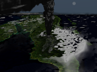
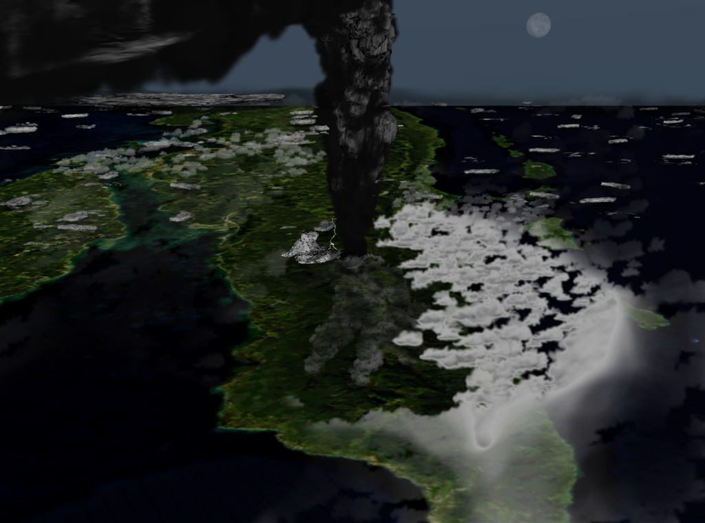
| Katarangan | Illustration of what the Toba eruption might have looked like around 42 km above northern Sumatra. |
| Tanggal | (UTC) |
| Sumber |
Karya surang
|
| Pambuek | Anynobody |
Lisensi
Ambo, pamegang hak cipta karya ko, basamo ko malakekan berkas ko jo lisensi barikuik:

|
Diizinan untuak manyalin, mandistribusian dan/atau mamodifikasi dokumen ko jo syaraik-syaraik Lisensi Dokumentasi Bebas GNU, Versi 1.2 atau labiah baru nan dikaluaan dek Free Software Foundation; tanpa Bagian Invarian, tanpa Teks Sampul Muko, dan tanpa Teks Sampul Balakang. Salinan lisensi dimasuakan ka bagian nan bajudul Lisensi Dokumentasi Bebas GNU. |
This file is licensed under the Creative Commons Attribution-Share Alike 4.0 International, 3.0 Unported, 2.5 Generic, 2.0 Generic and 1.0 Generic license.
- Sanak bebas:
- untuak babagi – untuak manyalin, manyebarkan, jo mangirimkan karya
- untuak mancampua – untuak mangadaptasi karya
- Di bawah kondisi barikuik:
- atribusi – Sanak musti maagiah atribusi karya ko jo caro nan ditantuan dek pambuek atau pamacik lisensi (tapi indak jo caro apo pun nan mancaminkan Sanak dipaso atau panggunoan Sanak pado karya tasabuik).
- babagi sarupo – Kok Sanak maubah, mangganti, atau mambuek turunan dari materi ko, Sanak musti manyebaluaskan jariah Sanak di bawah lisensi nan samo jo materi asali.
Sanak dapek mamiliah lisensi surang.
Riwayaik berkas
Klik pado tanggal/wakatu untuak mancaliak berkas pado maso tu.
| Tanggal/Wakatu | Miniatur | Dimensi | Pangguno | Komentar | |
|---|---|---|---|---|---|
| kini ko | 19 Agustus 2009 07.39 | | 1.620 × 1.200 (1,43 MB) | Anynobody~commonswiki | oops, last upload was a study, this is what I meant to upload |
| 17 Agustus 2009 10.00 |  | 1.845 × 1.494 (941 KB) | Anynobody~commonswiki | lighter, better plume and weather | |
| 6 Nopember 2008 09.30 |  | 1.750 × 1.312 (1,7 MB) | Anynobody~commonswiki | new version/perspective | |
| 8 Agustus 2008 10.16 |  | 1.550 × 1.372 (2,2 MB) | Anynobody~commonswiki | highlighting compass rose | |
| 12 April 2008 13.26 |  | 1.550 × 1.372 (2,2 MB) | Anynobody~commonswiki | added subtle compass rose | |
| 10 Pebruari 2008 15.00 |  | 1.550 × 1.372 (2,19 MB) | Anynobody~commonswiki | {{Information |Description=Illustration of what the last major Toba eruption looked like. |Source=self-made |Date= ~~~~~ |Author= Anynobody |Permission= |other_versions= }} |
Pamakaian berkas
Laman nan mamakai berkas ko:
Pamakaian berkas global
Wiki nan mamakai berkas ko:
- Pamakaian pado ar.wikipedia.org
- Pamakaian pado be.wikipedia.org
- Pamakaian pado bg.wikipedia.org
- Pamakaian pado bn.wikipedia.org
- Pamakaian pado cs.wikipedia.org
- Pamakaian pado en.wikipedia.org
- Pamakaian pado es.wikipedia.org
- Pamakaian pado eu.wikipedia.org
- Pamakaian pado fa.wikipedia.org
- Pamakaian pado fr.wikipedia.org
- Pamakaian pado id.wikipedia.org
- Pamakaian pado it.wikipedia.org
- Pamakaian pado ja.wikipedia.org
- Pamakaian pado ko.wikipedia.org
- Pamakaian pado ms.wikipedia.org
- Pamakaian pado pt.wikipedia.org
- Pamakaian pado ro.wikipedia.org
- Pamakaian pado sv.wikipedia.org
- Pamakaian pado ta.wikipedia.org
- Pamakaian pado te.wikipedia.org
- Pamakaian pado tl.wikipedia.org
- Pamakaian pado tr.wikipedia.org
- Pamakaian pado tt.wikipedia.org
- Pamakaian pado uk.wikipedia.org
- Pamakaian pado zh.wikipedia.org