Berkas:Mount Mazama eruption timeline.PNG
Ukuran nan usali (250 × 841 piksel, ukuran berkas: 187 KB, tipe MIME: image/png)
Ikhtisar
| Katarangan |
|
| Sumber | http://pubs.usgs.gov/fs/2002/fs092-02/ (saved as PNG) |
| Pambuek | U.S. GEOLOGICAL SURVEY and the NATIONAL PARK SERVICE |
| Versi lain |
    |
Lisensi
Gambar ini berada di domain umum di Amerika Serikat karena gamabar ini hanya mengandung bahan yang asli berasal dari Survei Geologi Amerika Serikat, sebuah badan Departemen Dalam Negeri Amerika Serikat. Untuk informasi lebih lanjut, lihat kebijakan hak cipta Survei Geologi Amerika Serikat resmi.
|
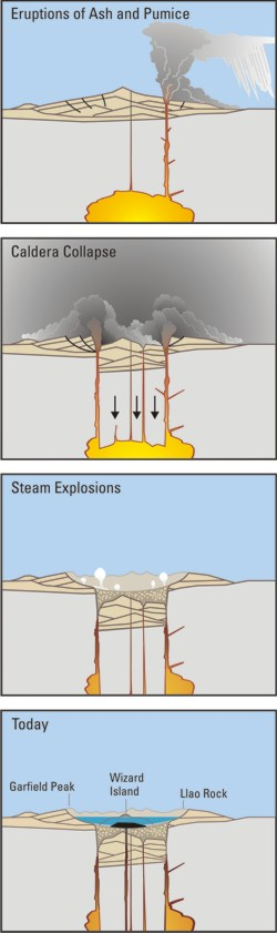
Crater Lake is an example, it is located in Oregen and was made from a valcano, making a caldera.
Riwayaik berkas
Klik pado tanggal/wakatu untuak mancaliak berkas pado maso tu.
| Tanggal/Wakatu | Miniatur | Dimensi | Pangguno | Komentar | |
|---|---|---|---|---|---|
| kini ko | 29 Maret 2006 12.24 | 250 × 841 (187 KB) | Jkelly | Source: http://pubs.usgs.gov/fs/2002/fs092-02/ (saved as PNG) Author: U.S. GEOLOGICAL SURVEY and the NATIONAL PARK SERVICE Description: <blockquote>Cataclysmic eruption to present. Eruptions of ash and pumice: The cataclysmic eruption started from a ve |
Pamakaian berkas
Laman nan mamakai berkas ko:
Pamakaian berkas global
Wiki nan mamakai berkas ko:
- Pamakaian pado af.wikipedia.org
- Pamakaian pado an.wikipedia.org
- Pamakaian pado ar.wikipedia.org
- Pamakaian pado ast.wikipedia.org
- Pamakaian pado br.wikipedia.org
- Pamakaian pado ce.wikipedia.org
- Pamakaian pado cy.wikipedia.org
- Pamakaian pado de.wikipedia.org
- Pamakaian pado en.wikipedia.org
- Pamakaian pado en.wikiversity.org
- Pamakaian pado eo.wikipedia.org
- Pamakaian pado es.wikipedia.org
- Pamakaian pado fa.wikipedia.org
- Pamakaian pado fi.wikipedia.org
- Pamakaian pado fr.wikipedia.org
- Pamakaian pado id.wikipedia.org
- Pamakaian pado it.wikipedia.org
- Pamakaian pado ja.wikipedia.org
- Pamakaian pado ko.wikipedia.org
- Pamakaian pado lv.wikipedia.org
- Pamakaian pado mk.wikipedia.org
- Pamakaian pado ml.wikipedia.org
- Pamakaian pado pt.wikipedia.org
- Pamakaian pado ru.wikipedia.org
- Pamakaian pado simple.wikipedia.org
- Pamakaian pado sk.wikipedia.org
- Pamakaian pado sr.wikipedia.org
- Pamakaian pado su.wikipedia.org
- Pamakaian pado vi.wikipedia.org
- Pamakaian pado www.wikidata.org