Berkas:Panama-Canal-rough-diagram-quick.jpg
Indak tasadio resolusi nan labiah gadang.
Panama-Canal-rough-diagram-quick.jpg (560 × 540 piksel, ukuran berkas: 57 KB, tipe MIME: image/jpeg)
Ikhtisar
| Katarangan |
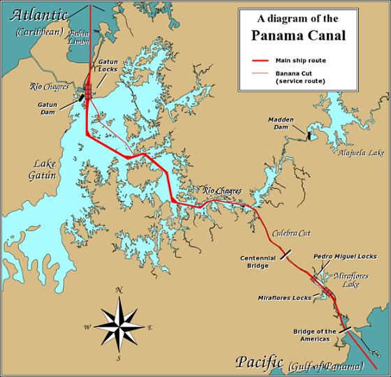
English: A diagram illustrating the layout of the Panama Canal (in quick JPEG format, auto-resizes to fit).
Due to the shape of the Isthmus of Panama, the Pacific end of the canal is actually the south-east end, and the Caribbean / Atlantic end is at the north-west. From the Pacific side, the Miraflores and Pedro Miguel locks (with two and one stages respectively) lead up to the highest level of the canal, 26 metres (85 feet) above sea level. The Culebra Cut (or Gaillard Cut) leads to Gatún Lake, created by damming the Chagres River; then the Gatún Locks lead back down to sea level in Limón Bay. The heavy red line shows the ship route. The narrower red line in Gatún Lake is the Banana Cut, a shortcut used by canal boats and yachts. |
| Tanggal | |
| Sumber | Source URL: Image:Panama_Canal_Rough_Diagram.png (GFDL file, reduced/retouched, saved JPEG format (5x faster than PNG), intended for use in frequently-read Wiki articles). |
| Pambuek | User:Johantheghost (JPEG version by Wikid77) |


Lisensi

|
Diizinan untuak manyalin, mandistribusian dan/atau mamodifikasi dokumen ko jo syaraik-syaraik Lisensi Dokumentasi Bebas GNU, Versi 1.2 atau labiah baru nan dikaluaan dek Free Software Foundation; tanpa Bagian Invarian, tanpa Teks Sampul Muko, dan tanpa Teks Sampul Balakang. Salinan lisensi dimasuakan ka bagian nan bajudul Lisensi Dokumentasi Bebas GNU. |
| Berkas iko di bawah lisensi Creative Commons Atribusi-BerbagiSerupa 3.0 Tanpa Adaptasi | ||
| ||
| Label lisensi ko ditambahkan pado berkas sabagai bagian dari pambaruan lisensi GFDL. |
Riwayaik berkas
Klik pado tanggal/wakatu untuak mancaliak berkas pado maso tu.
| Tanggal/Wakatu | Miniatur | Dimensi | Pangguno | Komentar | |
|---|---|---|---|---|---|
| kini ko | 27 Desember 2006 00.28 | | 560 × 540 (57 KB) | Wikid77 | == Summary == A diagram illustrating the layout of the Panama Canal (in quick JPEG format, auto-resizes to fit). Due to the shape of the Isthmus of Panama, the Pacific |
Pamakaian berkas
Laman nan mamakai berkas ko:
Pamakaian berkas global
Wiki nan mamakai berkas ko:
- Pamakaian pado ar.wikipedia.org
- Pamakaian pado cdo.wikipedia.org
- Pamakaian pado cs.wikipedia.org
- Pamakaian pado de.wikipedia.org
- Pamakaian pado en.wikipedia.org
- Pamakaian pado es.wikipedia.org
- Pamakaian pado fi.wikipedia.org
- Pamakaian pado fr.wikipedia.org
- Pamakaian pado gor.wikipedia.org
- Pamakaian pado hu.wikipedia.org
- Pamakaian pado id.wikipedia.org
- Pamakaian pado jv.wikipedia.org
- Pamakaian pado km.wikipedia.org
- Pamakaian pado li.wikipedia.org
- Pamakaian pado map-bms.wikipedia.org
- Pamakaian pado mn.wikipedia.org
- Pamakaian pado simple.wikipedia.org
- Pamakaian pado th.wikipedia.org
- Pamakaian pado ur.wikipedia.org
- Pamakaian pado vi.wikipedia.org
- Pamakaian pado www.wikidata.org
- Pamakaian pado zh.wikinews.org