Berkas:IndoChina1886.jpg
Ukuran nan usali (1.573 × 2.079 piksel, ukuran berkas: 875 KB, tipe MIME: image/jpeg)
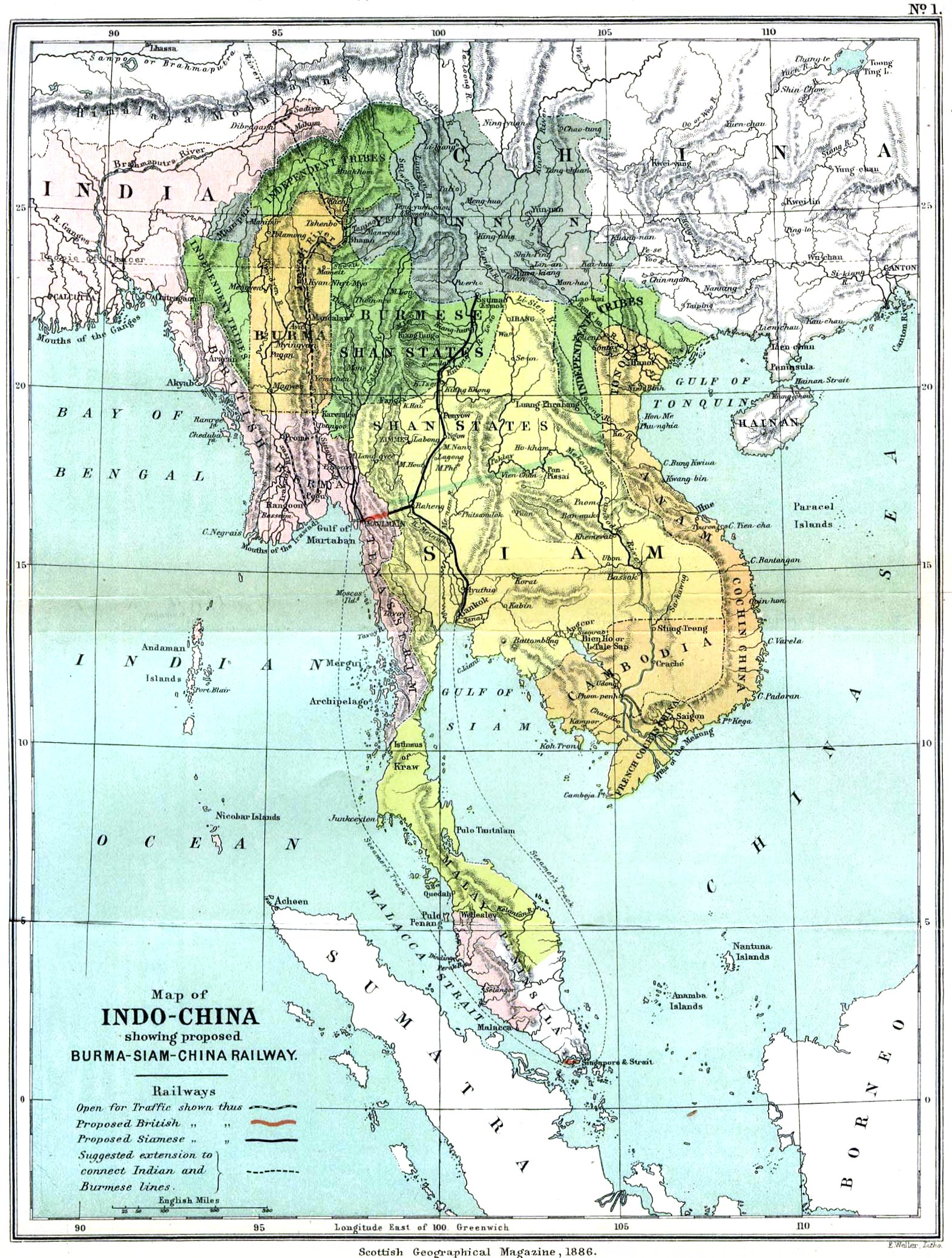
Source: Scottish Geographical Magazine, 1886
map of Indochina
Original version: File:Indochina map 1886.jpg
|
This work is in the public domain in its country of origin and other countries and areas where the copyright term is the author's life plus 70 years or fewer.
| |
| Berkas ini telah diidentifikasi bebas dari pembatasan menurut hukum hak cipta termasuk semua hak terkait dan relevan. | |
Riwayaik berkas
Klik pado tanggal/wakatu untuak mancaliak berkas pado maso tu.
| Tanggal/Wakatu | Miniatur | Dimensi | Pangguno | Komentar | |
|---|---|---|---|---|---|
| kini ko | 21 Maret 2006 07.53 | | 1.573 × 2.079 (875 KB) | Julo | Indochina, map of 1886 {{PD-old}} category:Historical maps of Asiacategory:maps of 19th century |
Pamakaian berkas
Laman nan mamakai berkas ko:
Pamakaian berkas global
Wiki nan mamakai berkas ko:
- Pamakaian pado ace.wikipedia.org
- Pamakaian pado af.wikipedia.org
- Pamakaian pado anp.wikipedia.org
- Pamakaian pado arz.wikipedia.org
- Pamakaian pado az.wikipedia.org
- Pamakaian pado be-tarask.wikipedia.org
- Pamakaian pado be.wikipedia.org
- Pamakaian pado bg.wikipedia.org
- Pamakaian pado bn.wikipedia.org
- Pamakaian pado br.wikipedia.org
- Pamakaian pado bs.wikipedia.org
- Pamakaian pado ca.wikipedia.org
- Pamakaian pado cs.wikipedia.org
- Pamakaian pado cv.wikipedia.org
- Pamakaian pado cy.wikipedia.org
- Pamakaian pado da.wikipedia.org
- Pamakaian pado en.wikipedia.org
- Pamakaian pado eo.wikipedia.org
- Pamakaian pado es.wikipedia.org
- Pamakaian pado et.wikipedia.org
- Pamakaian pado fa.wikipedia.org
- Pamakaian pado fr.wikipedia.org
- Pamakaian pado fy.wikipedia.org
- Pamakaian pado gl.wikipedia.org
- Pamakaian pado gn.wikipedia.org
- Pamakaian pado he.wikipedia.org
- Pamakaian pado hi.wikipedia.org
- Pamakaian pado hr.wikipedia.org
- Pamakaian pado hu.wikipedia.org
- Pamakaian pado hy.wikipedia.org
- Pamakaian pado ilo.wikipedia.org
- Pamakaian pado io.wikipedia.org
- Pamakaian pado is.wikipedia.org
- Pamakaian pado it.wikipedia.org
- Pamakaian pado kk.wikipedia.org
Calaik labiah banyak panggunoan global dari berkas ko.